CAPLA-led Research Team Awarded $150K NOAA Grant to Help American Communities Better Plan for Heat Mitigation

Across the United States, heat-related deaths are on the rise, with over 700 deaths and tens of thousands of emergency room visits each year. While many states and local governments are developing strategies to address urban heat, there is little collaboration within communities—and that’s a problem.

Ladd Keith, University of Arizona Associate Professor of Planning and Sustainable Built Environments.
The lack of coordination on urban heat resilience “can result in ineffective heat mitigation, or worse, contribute to urban heat in areas of highest risk,” says Ladd Keith, assistant professor of planning and sustainable built environments in the College of Architecture, Planning and Landscape Architecture at the University of Arizona.
To help bridge these disparate efforts, Keith is leading an effort called Plan Integration for Resilience Scorecard for Heat, or PIRSH, that has been awarded a $150,000 grant from the U.S. National Oceanic and Atmospheric Administration’s Climate Program Office, under its Extreme Heat Risk Initiative. NOAA sought proposals that “address research gaps to improve our understanding of how and why urban heat varies and to inform decisions about interventions to address it.”
The grant was awarded to the research team led by Keith, which also includes Sara Meerow of Arizona State University, Philip Berke of the University of North Carolina at Chapel Hill and Joseph DeAngelis of the American Planning Association (APA).
The team’s research will build from the Plan Integration for Resilience Scorecard (PIRS) methodology, which was recently adopted by the APA as a national standard and resource for building local capacity to integrate resilience across planning sectors. However, while the PIRS approach has been applied in the U.S. and internationally for flood planning, it has not yet been applied to heat hazards.
Enter PIRSH, a methodology piloted in Tucson, Arizona that will now be expanded to five other geographically distinct U.S. cities: Baltimore, Boston, Fort Lauderdale, Houston and Seattle.
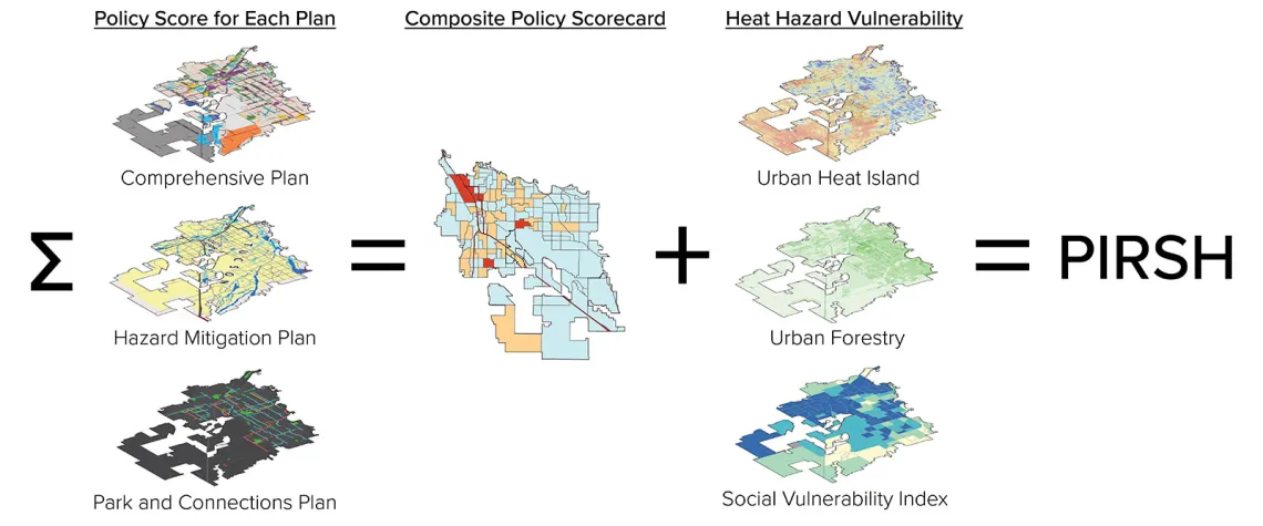
“PIRSH will help communities systematically evaluate their current heat mitigation strategies across relevant plans, compare the combined effect of those strategies with heat risk data and identify opportunities for improved planning,” says Keith. “This will help communities bring together traditionally siloed disciplines and align their urban heat resilience efforts to reduce the negative health, economic and environmental impacts of heat.”

Image courtesy Ladd Keith.
Keith, Meerow, Berke and DeAngelis will determine what types of policies are relevant to heat vulnerability and how effective strategies are in mitigating risks. To find these answers, they are surveying experts “across critical professions and in diverse geographies,” says Keith.
The team will then collect Baltimore, Boston, Fort Lauderdale, Houston and Seattle city plans and identify, categorize and score the heat-relevant policies from these plans, mapping where they apply across each city. Scores will then be summed for different areas and the resulting scorecard will be overlayed with urban heat island maps to determine how policies spatially align with heat risks.
The methodology’s use of NOAA’s urban heat island mapping campaigns will “help partner communities by using the maps to inform and coordinate their planning for urban heat resilience efforts,” says Keith.
To assist with their work the team will hire two graduate student research assistants: Erika Schmidt, a UArizona Master of Architecture student who has worked with Keith on previous NOAA heat planning projects, and Shaylynn Trego, an incoming PhD student in geography at Arizona State University. The students will independently analyze the city plans and then reconcile scores to ensure consistency.
Stakeholders within the cities will also be engaged at strategic points, say the researchers, which will “improve the implementation of the extreme heat risk mitigation, preparation and response strategies informed by the PIRSH methodology.”
Once their research is complete, the team will develop a publicly available PIRSH guidebook, sharing the methodology and results with the NOAA community and broader networks. Because of the team’s partnership with APA—Keith and Meerow are leading APA’s first Planning Advisory Service report on heat titled Planning for Urban Heat Resilience, and DeAngelis is a senior research associate with APA Chicago—the APA will help disseminate the PIRSH methodology to over 46,000 APA members across the U.S. and beyond.
“Effectively governing extreme heat risk requires a novel, integrated planning approach,” concludes Keith. “The PIRSH methodology will increase coordination across community plans, enable the development of scalable frameworks and tools to aid planners and help prioritize the most effective heat mitigation strategies.”
Header photo by Rogerio Rogeriomda, courtesy Pixabay.


