
Interdisciplinary team named finalists in 2024 ArcGIS StoryMaps Competition
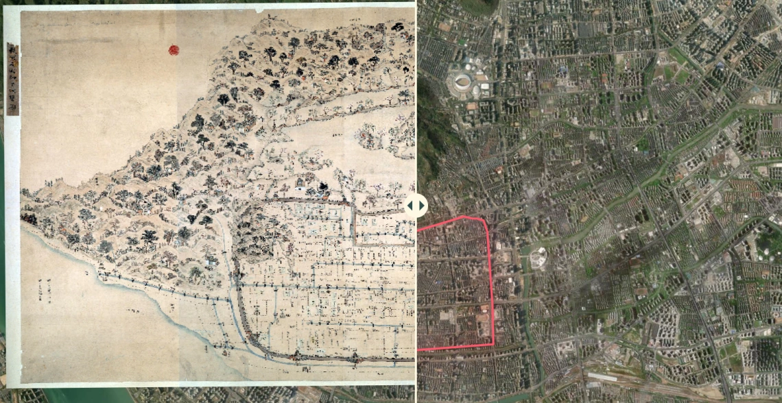
Using GIS, the CAPLA team mapped Buddhist religious sites in Hangzhou, China, illustrating how these sites are interconnected within a regional system that can be further studied and visualized.
An interdisciplinary team of faculty and students from the College of Architecture, Planning, and Landscape Architecture (CAPLA) and the College of Humanities has been named a finalist in the international 2024 ArcGIS StoryMaps Competition.
This year, over 570 storytellers from 58 countries submitted entries in 10 languages for the competition.
Their submission, Regional Religious Systems in Hangzhou, China, demonstrates an innovative use of Geographic Information Systems (GIS) technology to explore the spatial dimensions of historical Buddhist religious sites and pilgrimage routes in the region.
GIS is a powerful tool for capturing, storing, analyzing, and visualizing spatial and geographic data. It helps researchers understand patterns, relationships, and trends in various fields, including urban planning, environmental management, transportation, and public health.
“I am incredibly proud of the team that worked on this project,” said Philip Stoker, associate professor of planning and co-lead on the project.
The project was a collaboration with Jiang Wu, director of the Center for Buddhist Studies in the College of Humanities. Wu has spent more than two decades collecting data on Chinese religious sites and developing the theory of Regional Religious Systems (RRS).
Using GIS, the CAPLA team mapped Buddhist religious sites in Hangzhou, China, illustrating how these sites are interconnected within a regional system that can be further studied and visualized.
The project originated when Wu attended a cartography workshop taught by Stoker at the University of Arizona library. During the event, Wu shared his historical GIS research, leading the two to develop a grant proposal to expand the work.
“We immediately connected after I attended his training program a few years ago and decided to collaborate on this project,” Wu said. “We provided our data and concepts, and he and his students focused on visualization, using the many techniques and color schemes that StoryMaps offers.”
Funded by a CAPLA Seed Grant, the team hired Glenn Ingram, then a student in the Master of Science in Urban Planning program, to help develop the website and maps for the StoryMap.
For Ingram, the project provided an opportunity to apply the skills he learned in the urban planning program to a digital storytelling project that combined GIS and history.
StoryMaps are a powerful tool for visual storytelling, particularly in fields like architecture, urban planning, and landscape architecture. They allow users to combine maps, images, text, and multimedia into an interactive narrative, making complex ideas more engaging and accessible.
“The Digital Atlas allowed us to push the boundaries of what the StoryMap platform is capable of,” Ingram said. “Additionally, the subject matter—the landscapes, history, and geography of Chinese Buddhism—was new to me. Exploring these themes through spatial analysis and digital storytelling was a fascinating intersection of GIS and history.”
The StoryMap project offers valuable insights into the spatial patterns of religious sites in Hangzhou, demonstrating their connections through pilgrimage routes and the Grand Canal.
Wu provided the conceptual framework and oversaw key stages of the project, including theoretical development, data collection, digitization, georeferencing, and visualization.
“We are very proud of the final product,” Wu said. “The data accuracy is remarkable, and its overlap with contemporary maps is impressive. The project highlights Hangzhou’s connections to neighboring regions and the evolution of city walls over time.”
By integrating expertise in religious studies, spatial analysis, and map visualization, Wu and Stoker’s collaboration showcases the potential of GIS to illuminate historical and cultural landscapes.
Their work can be found here: https://storymaps.arcgis.com/stories/6f1fc88e594c4f1d9282c239fff08131
And all finalists are featured here: https://www.esri.com/arcgis-blog/products/arcgis-storymaps/announcements/vote-for-your-favorite-2024-arcgis-storymaps-competition-finalist/


