MS Urban Planning Student Wins Best Student Map Award from Arizona Geographic Information Council
A former wildland firefighter, Glenn Ingram ’23 MS Urban Planning has a passion for preparing for natural disasters. Naturally, when he considered a topic for the data, research and map creation assignment in his GIS for Landscape Architecture and Planning course, risk was front and center.
“I decided to look at flooding and population in major cities that could be impacted by sea rise in the future,” he says. “This map specifically looked at population density in New York City and the FEMA 100-year floodplain. By showing both of these pieces of data simultaneously, I was able to highlight areas of risk based on high flood risk and high population density.”
That “interesting topic or idea, engaging user experience and overall design and creativity,” according to award criteria, set Ingram’s project apart when he submitted it to the 2021 Arizona Geographic Information Council Maps & Apps Contest. Ingram’s “New York City 100-Year Floodplain” map was selected as the Best Student Map among all collegiate entries.
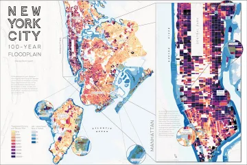
The AGIC award-winning New York City 100-Year Floodplain poster by Glenn Ingram.
Ingram’s project required searching for data, creating map elements in ArcGIS Pro and completing the design in Adobe Illustrator. “The map-making process itself can often feel a bit tedious and time-consuming, so I was grateful to have the opportunity to have my work recognized,” he says.
“In this map, Glenn demonstrates professional map design and clear communication of data,” says Philip Stoker, assistant professor of landscape architecture and planning and the GIS course instructor. “Submitting to competitions like this provides a broader audience for his excellent map design, and illustrates that better design is more than just cosmetic—it actually improves the communication of important information.”
Communication is critical in mapmaking and relates both to overall design and such factors as colors and visual hierarchy, layout and balance, and even particular components such as titles, fonts, labels and legends, says Stoker.
Not only is Ingram delighted to learn that he won the statewide award, he is also “excited to connect with the Arizona GIS community and hopeful that this might lead to more cartography work in the future,” he says.
Ingram is in the first year of the two-year Master of Science in Urban Planning program at the University of Arizona’s College of Architecture, Planning and Landscape Architecture. He plans to study environmental planning, with a specific focus on the intersection of the built and natural environment—particularly in the context of environmental disturbances.
Map Gallery
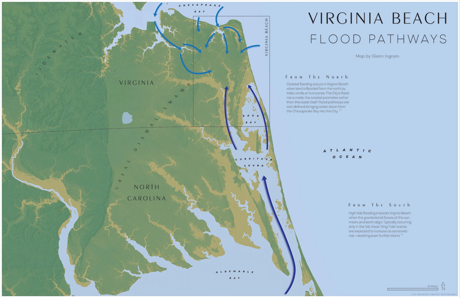
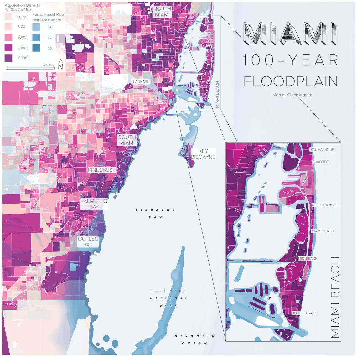
View more maps by Ingram created for his GIS for Landscape Architecture and Planning assignment: